Lake Tahoe Road Trip: Emerald Bay, Sand Harbor & South Lake
Watch the Lake Tahoe Road Trip video distraction-free 0:24
The road around Lake Tahoe is only about 72 miles, short enough to drive in an afternoon without stopping. Yet it crosses the California–Nevada line twice and stays above 6,000 feet the whole way. Roughly two-thirds of the lake sits in California and the rest in Nevada.
These four stops are spaced around that single loop. You can base yourself in South Lake Tahoe, which recently topped a where-to-travel-in-2027 ranking, or move around the shore and sleep somewhere new each night. The trip suits hikers, paddlers, mountain bikers and skiers, and anyone happy to trade lazy mornings for early starts.
Listen to this guide
Prefer to listen? This guide is also a 6-minute episode of our podcast.

Also available as Trip Ideas by Ottimo AI on Spotify, Apple Podcasts and other podcast apps.
South Lake Tahoe & Heavenly
Why Visit
At Heavenly you can ski from California into Nevada and back on the same run. The resort straddles the state line, and so does the town below it. On one side of a single street are California motels. On the other are Nevada casino towers.
That split comes from law. Nevada legalised gambling in 1931, so casinos packed in right at the border at Stateline. Then, in 1969, both states and Congress created the Tahoe Regional Planning Agency, the first bi-state environmental planning body in the country. It sharply limited new building. That is why the high-rises stop dead at the line and the rest of town stays low.
The lake itself formed when faults dropped a block of land between two rising ranges. It is up to 1,645 feet (501 metres) deep. It holds enough water to cover all of California about 14 inches deep.
When to Travel
At lake level, summer days reach the upper 70s to low 80s F (25 to 28 C) and nights drop into the 40s F. Late-summer afternoons can bring thunderstorms. In some years, wildfire smoke drifts in. Most snow falls between November and March, and ski season usually runs from late November into April.
Crowds peak around the Fourth of July, when fireworks go off over the lake. They also peak through August and on winter holiday weekends. September is the best shoulder month. The water is at its warmest, the kids are back in school, and the weather is usually dry. Give South Lake two days in summer, or three if you're skiing.
What Not to Miss
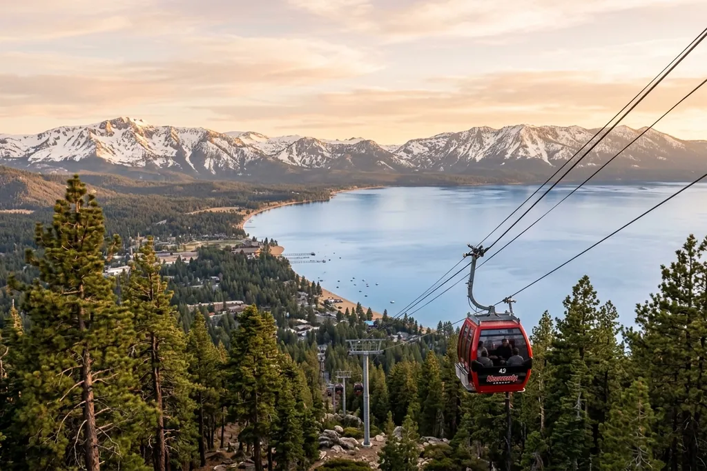
The Heavenly gondola climbs from beside the casinos to above 9,000 feet. Ride it in summer too. From the top you can see the full 22-mile length of the lake, plus the Carson Valley desert on the Nevada side. Go at opening, before afternoon cloud builds over the peaks.
The Tallac Historic Site preserves three lakeside estates from the early 1900s, when wealthy San Francisco families summered here. In October, the Taylor Creek visitor centre next door is the place to watch red kokanee salmon spawn. You can see them through an underground stream-profile window.
For dinner, drive over Kingsbury Grade and down into the valley to Gardnerville, well under an hour away. Basque sheepherders settled the Carson Valley in the late 1800s. Their family-style dinners are still served at long shared tables. Order a picon punch, a bitter amber cocktail you'll rarely find outside Nevada and California Basque restaurants.
Takeaway
Arrive on Friday before noon and leave on Sunday morning, not afternoon. US 50 back toward Sacramento turns into a crawl by early afternoon on summer and ski weekends, and chain controls make winter Sundays worse.
Emerald Bay State Park
Why Visit
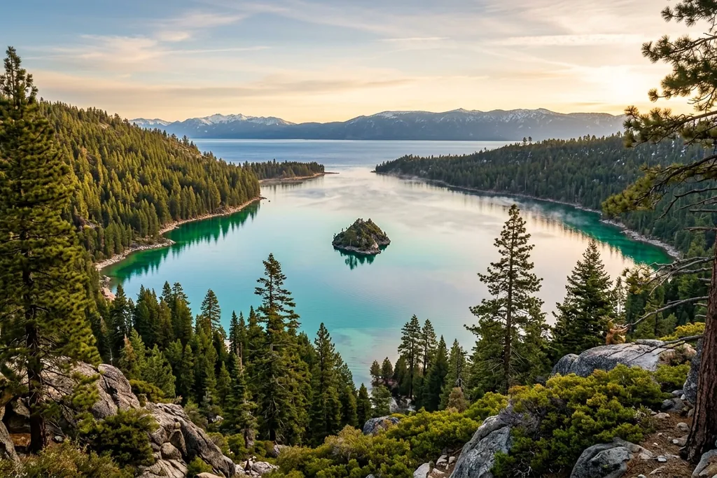
Lake Tahoe has exactly one island, Fannette, and it sits inside Emerald Bay. On its summit are the stone ruins of a tiny teahouse. In the late 1920s, the heiress Lora Knight had guests rowed out there for afternoon tea. Her family was also among the backers of Charles Lindbergh's famous transatlantic flight.
The bay is a glacier's work. Ice carved the basin, then left a ridge of rubble, called a moraine, across its mouth. That ridge makes a shallow sill, so the entrance is narrow and the water over the sandy bottom glows green. Out in the open lake, the same water looks deep blue.
On the shore below, Knight built Vikingsholm, a 38-room house modelled on Scandinavian churches and farmhouses. It has a sod roof that sprouts grass and wildflowers in spring. She chose the style because the fjord-like bay reminded her of Norway.
When to Travel
Emerald Bay is a summer place. Highway 89 runs along a narrow ridge above the bay and closes after heavy snow, often for days at a time between December and March, because of avalanche risk. Vikingsholm tours run only in summer, roughly late May to late September. Fannette Island is closed through spring while Canada geese nest there.
July and August days reach the upper 70s F, but the water stays bracing well below the surface. Crowds are heaviest from mid-morning to late afternoon on weekends. Early September has the same weather with fewer people. One full day is enough, two if you camp at the boat-in sites on the north shore.
What Not to Miss
Stop at Inspiration Point first for the classic overhead view of the island. Then walk down to Vikingsholm. The trail is about a mile and steep, and the climb back up takes twice as long as the descent. Bring water.
The Rubicon Trail is the best hike on the lake. It runs about 4.5 miles from D.L. Bliss State Park to Vikingsholm, mostly right along the shoreline. In places you look down into water clear enough to count rocks 30 feet below. Across the highway, Eagle Falls drops toward the bay, and a short, steep trail leads to Eagle Lake above it.
There's nowhere to eat at the bay, so pack a picnic. Fill your bottle before you come. Several lakeside water systems around Tahoe hold rare federal waivers to serve lake water without filtration, because it is that clean.
Takeaway
The Vikingsholm and Eagle Falls lots fill by around 9am on summer weekends. Either arrive before then or paddle in by kayak from the beaches near D.L. Bliss. In shoulder season, check Caltrans road conditions for Highway 89 before you drive around.
Sand Harbor & the East Shore (Nevada)
Why Visit
Most of Tahoe's Nevada shore is empty because of one eccentric millionaire. In the 1930s, George Whittell Jr. bought a huge stretch of the east shore and refused to develop it. Much of that land later passed to the state and the Forest Service. That's why Highway 28 runs past miles of forest and coves instead of houses.
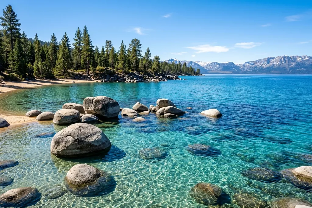
The giant rounded boulders at Sand Harbor are granite from the Sierra Nevada batholith, rock that cooled deep underground. Water seeping into cracks weathers the corners first, which leaves the smooth, piled shapes you see. The lake bed is the same coarse granite sand. It holds few nutrients for algae, which is a big reason Tahoe is so clear.
That clarity is slipping, though. In the late 1960s, a white disk lowered into the lake stayed visible past 100 feet. Today it vanishes at closer to 60 or 70 feet, mostly because of fine sediment and algae from runoff.
When to Travel
The east shore is drier and sunnier than the west, and it gets noticeably less snow. July and August highs sit in the upper 70s to low 80s F. Surface water can reach the upper 60s F in the coves by late summer, which is as warm as Tahoe gets.
The Lake Tahoe Shakespeare Festival runs at Sand Harbor through the height of summer. Performances are on a stage with the lake behind it, and the tradition dates back several decades. September is the sweet spot: warm water, open parking and calm mornings. Allow one day, or two if you add the Flume Trail.
What Not to Miss
Spend a morning at Sand Harbor. Swim or paddle between the boulders while the water is glassy, before the afternoon wind picks up. The Tahoe East Shore Trail, a paved path of about 3 miles from Incline Village, lets you walk or cycle in without needing a parking space.
South along Highway 28, small roadside pullouts lead down to quieter coves, including Secret Cove, which is clothing-optional. Further south, US 50 tunnels through Cave Rock, a volcanic plug sacred to the Washoe people. Climbing it is banned.
Mountain bikers should ride the Flume Trail. It follows the route of an old wooden flume built to move water and timber for the Comstock silver mines in the late 1800s, and that era's logging stripped most of the basin bare. In autumn, look for roadside sellers of roasted pine nuts. They come from single-leaf pinyon in the Nevada ranges, a Washoe staple for thousands of years.
Takeaway
Sand Harbor's gate closes once the lot is full, often by mid-morning in summer. Be there before 9am or come by bike on the East Shore Trail. If you book Shakespeare tickets, bring a warm jacket, because it gets cold by the second act.
Tahoe City & Palisades Tahoe
Why Visit
About 63 streams flow into Lake Tahoe, but only one river flows out. It leaves at Tahoe City, through a small dam. The dam controls only the top 6 feet or so of the lake. The Truckee River then runs into Nevada and ends in Pyramid Lake in the desert, never reaching the sea.
The bridge over the outlet is nicknamed Fanny Bridge. The name comes from the row of backsides belonging to people leaning over the railing to look at trout.
A short drive away, Palisades Tahoe, long known as Squaw Valley, won the 1960 Winter Olympics when it had a single chairlift. Walt Disney staged the opening ceremony. These were the first Winter Games broadcast live on US television, and the first to tally results by computer. The resort typically gets around 400 inches of snow a year.
When to Travel
Winter is serious here. The upper mountain at Palisades sits above 8,000 feet, and big Pacific storms can drop several feet of snow in a day. Ski season usually runs from late November into spring. The deepest, most reliable snow tends to fall in February and March.
Summer brings highs in the upper 70s F. River rafting runs roughly June to September, depending on how much water the dam releases. Crowds peak on powder weekends and in July and August. Late September and early October are quiet, with aspens turning gold. Give it two days in summer, or three to four for a ski trip.
What Not to Miss
Float the Truckee from Tahoe City. It's a gentle stretch of about 5 miles that takes two to three hours, with no whitewater. Start early, before mid-afternoon, when the river fills with rafts and tubes.
At Palisades, ride the aerial tram to High Camp, around 8,200 feet, in any season. In winter, expert skiers head for KT-22, the steep peak that built the resort's reputation. In summer, walk among the aspens of nearby meadows. Some trees still carry carvings left by Basque sheepherders who grazed flocks here a century ago.
For something local to eat, book a morning fishing charter out of Tahoe City for Mackinaw, or lake trout, which live deep and grow large. They were stocked in the late 1800s. The native Lahontan cutthroat vanished from the lake by the late 1930s, so Mackinaw is now the fish Tahoe is known for.
Takeaway
On winter weekends, check whether Palisades requires parking reservations, and book them before you drive up. If the lot is full, take the free shuttles from Tahoe City instead of joining the queue on Highway 89.
Drive the loop clockwise: South Lake Tahoe, then Emerald Bay, Tahoe City and Palisades, the East Shore, and back to South Lake. Going this way keeps the lake on your right, so scenic pullouts are easy right turns rather than turns across traffic. A summer trip needs about six days to see everything without rushing, and a ski trip needs eight or more. Book accommodation well ahead for summer and holiday weekends, because beds around the lake are limited.
Frequently Asked Questions
Is South Lake Tahoe & Heavenly worth visiting?
Yes, South Lake Tahoe & Heavenly is well worth a visit, especially if you love big views and quirky history. You can ski from California into Nevada on a single run, and the Heavenly gondola, worth riding even in summer, reveals the full 22-mile lake. Give it two days in summer, or three if you're skiing.
When is the best time to visit Emerald Bay State Park?
Summer is the best time to visit Emerald Bay State Park, and early September offers the same warm weather with fewer crowds. Vikingsholm tours run only in summer, and Highway 89 above the bay can close for days after heavy winter snow. Arrive early on weekends, since parking lots fill fast, and plan on one full day.
What is Sand Harbor on Lake Tahoe known for?
Sand Harbor is known for its giant, smooth granite boulders piled along impossibly clear water on Tahoe's Nevada shore. The rounded shapes formed as water weathered cracks in Sierra Nevada granite. The surrounding East Shore feels refreshingly wild, too, because a millionaire landowner refused to develop it, and much of that land later passed to the state and the Forest Service.